
In this second phase of my CCS suitability analysis, I shifted focus from hypothetical modeling to something more grounded: where natural conditions in the U.S. already support the potential for Direct Air Capture (DAC).
Rather than create another suitability model with Python — which proved impractical given the format of my source data — I opted for a vector-based approach. Using polygon shapefiles representing onshore wind speed, solar photovoltaic capacity, and two forms of ideal CO₂ storage geology (saline reservoirs and depleted oil fields), I identified regions where these elements intersect in meaningful ways.
The Method
Using standard GIS overlay tools like Intersect, I filtered:
- Wind polygons with average speeds ≥ 10 mph (highly suitable for powering DAC fans),
- Solar zones with photovoltaic potential > 6 kWh/m²/day, and
- CO₂ storage geology from the NATCARB dataset, split into saline formations and depleted oil/gas reservoirs.
The goal: find where renewable energy and ideal storage geology co-occur — the kind of synergy that makes DAC logistically and environmentally viable.
Early Findings
While high-potential solar zones were relatively abundant — particularly in the southwestern United States — high wind zones were far rarer. In fact, only a handful of regions met the strict ≥10 mph threshold and overlapped with geologically viable storage. One surprising hotspot? Western Montana, where high wind zones happen to align with underlying saline formations — making it a stealth contender for future DAC siting.
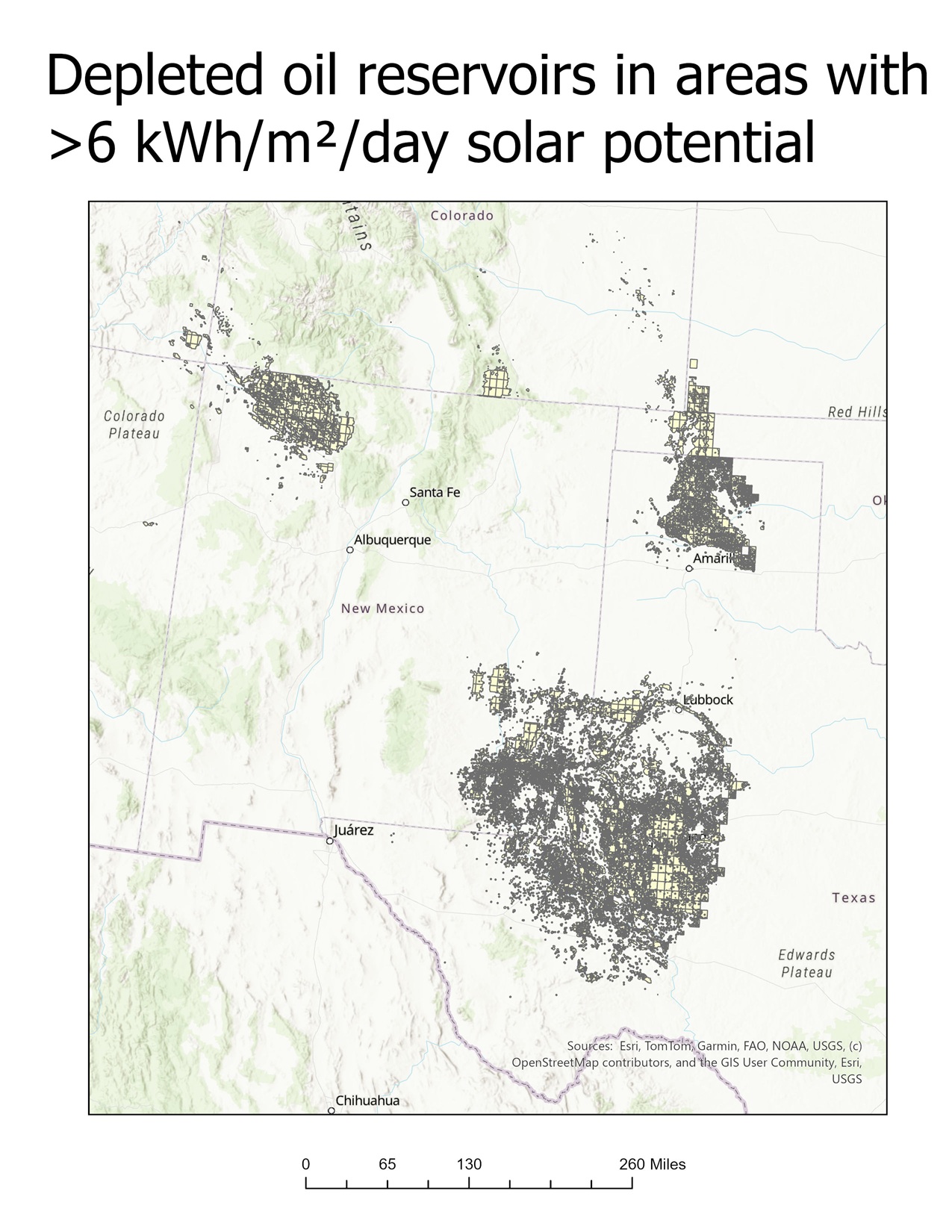
By contrast, the depleted oil reservoir regions of Texas and northwest New Mexico aligned more predictably with high solar capacity. These regions may be less headline-grabbing than offshore wind or solar megaprojects, but they offer a practical advantage: existing infrastructure and legacy pipelines could be repurposed for carbon injection.
Reflections & What’s Next
This first-pass spatial analysis highlights just how geographically constrained Direct Air Capture can be when relying on naturally favorable conditions alone. While there are promising overlaps — such as the Idaho/Montana wind corridor and the solar-rich oil basins of Texas — they’re relatively limited in number and require strategic coordination between energy availability and subsurface geology.
It also raises a broader question:
What if instead of chasing the ideal intersection of natural resources, we went straight to where ongoing emissions are already concentrated?
That’s the core premise behind Point Source Capture — the other major branch of carbon capture technology. Unlike DAC, which pulls carbon directly from ambient air, point source systems capture CO₂ from high-emission sites like power plants, cement factories, and refineries before it ever enters the atmosphere, whilst still allowing for those facilities to continue to do the things which are essential to keeping modern civilization running, like providing electricity.
In the next post, I’ll explore how Point Source Capture compares to DAC in terms of:
- Geographic feasibility
- Energy efficiency
- Infrastructure needs
- Integration with existing industrial hubs
By mapping large-scale emission sources and comparing their proximity to CO₂ storage geology, I’ll begin to answer the bigger question:
Which approach makes more sense where — and why?