Original Hypothesis
The Pacific Northwest is at significant risk from the future Cascadia Megaquake and Tsunami, and effective mapping using GIS can enhance disaster preparedness by identifying evacuation routes and highlighting infrastructure vulnerabilities. My hypothesis was that GIS technology, combined with community-led mitigation efforts, could substantially reduce the potential loss of life and property.
Research Journey
Through a series of blog posts, I documented my research and mapping efforts to understand the Cascadia Subduction Zone and its potential impacts. My journey involved:
- Understanding the Threat: The Cascadia Subduction Zone is a 700-mile fault line capable of generating a magnitude 9.0 earthquake and a massive tsunami. This event, expected every 300-500 years, poses severe risks to coastal communities. I explored historical data and geological evidence to understand the scope of the disaster.
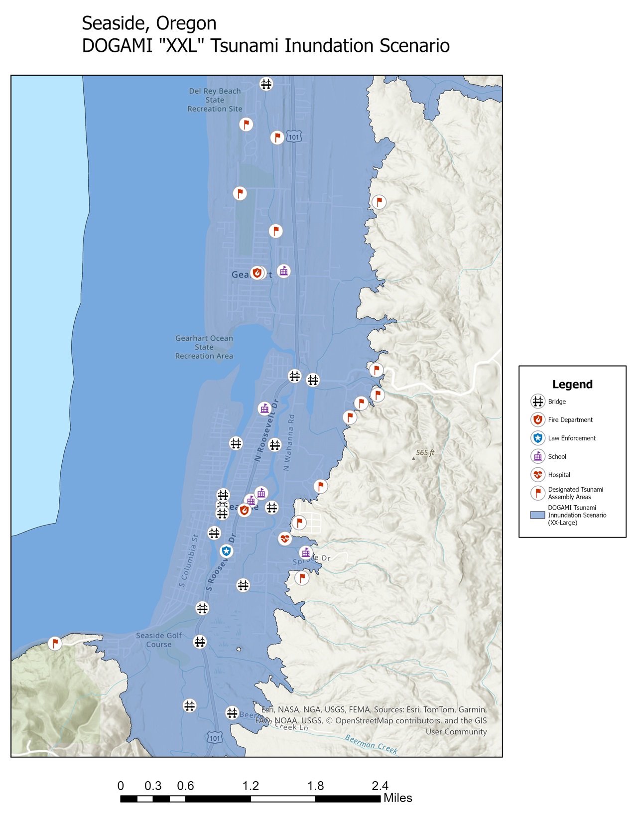
- DOGAMI’s “XXL” Tsunami Inundation Zones: Using data from the Oregon Department of Geology and Mineral Industries (DOGAMI), I analyzed inundation zones for an “XXL” tsunami scenario. These zones represent worst-case scenarios for tsunami reach, emphasizing the need for precise evacuation planning and robust mitigation infrastructure.
- Case Studies of Seaside, Oregon, and Westport, Washington: These towns exemplify proactive disaster preparedness. Seaside has invested in a new school campus outside the inundation zone to provide refuge during a tsunami, while Westport has developed a tsunami tower—the first of its kind in the United States. Both towns have detailed evacuation routes and public education programs.
- Mapping Evacuation Routes: Using ArcGIS, I created evacuation maps to visualize safe pathways from high-risk zones to safe areas. These maps incorporated elevation data, proximity to tsunami inundation zones, and existing road networks. This process highlighted the importance of accessible evacuation options, particularly for vulnerable populations.
Conclusions and Lessons Learned
Key Findings
- Preparedness is Crucial: Towns like Seaside and Westport demonstrate that early investments in infrastructure and planning can save lives.
- GIS as a Tool for Resilience: GIS technology proved indispensable in visualizing risks, planning evacuation routes, and communicating potential hazards to communities.
- Community Involvement: Effective disaster mitigation requires collaboration between government agencies, scientists, and local residents.
Reflections
My work reaffirmed the value of spatial analysis in disaster management. Mapping not only informs policy decisions but also empowers communities to take action. By creating these maps, I hope to contribute to a broader effort to enhance resilience in the face of the Cascadia Megaquake and Tsunami.
This project has deepened my understanding of how GIS can bridge the gap between scientific research and actionable community resilience strategies.
References
- DOGAMI data for tsunami inundation zones.
- U.S. Geological Survey (USGS) for earthquake and tsunami risk data.
- Local government resources from Seaside, Oregon, and Westport, Washington, detailing evacuation infrastructure and planning efforts.
Supporting Blogs
-
Mapping for Resilience: Understanding the Cascadia Megaquake & Tsunami
The Pacific Northwest sits atop a ticking geological time bomb: the Cascadia Subduction Zone. This massive fault line, stretching over 700 miles from Northern California to British Columbia, has the potential to unleash one of the most catastrophic natural disasters in modern history—an earthquake of magnitude 8.0 to 9.2 and accompanying tsunami. Scientists warn that…
-
Mapping for Resilience: DOGAMI’s “XXL” tsunami inundation zone
Examining the Risks: A tsunami in Seaside, Oregon Seaside, a popular Oregon town for beachgoers, sits on the frontlines of one of the Pacific Northwest’s most significant natural hazards: the Cascadia Subduction Zone. In the event of a megathrust earthquake of magnitude 8.0+, the resulting tsunami could devastate coastal communities. Using ArcGIS and data provided…
-
Mapping For Resilience: Comparing Tsunami Preparedness in Seaside, Oregon & Westport, Washington
When it comes to tsunami preparedness, coastal communities must adapt to their unique geographies and resources to protect residents and visitors. In this post, I compare two towns with different approaches to managing tsunami risks: Seaside, Oregon, and Westport, Washington. Using data from the Oregon Department of Geology and Mineral Industries (DOGAMI) for Seaside and…
-
Mapping for Resilience: Final Report – Understanding the Cascadia Megaquake and Tsunami
Original Hypothesis The Pacific Northwest is at significant risk from the future Cascadia Megaquake and Tsunami, and effective mapping using GIS can enhance disaster preparedness by identifying evacuation routes and highlighting infrastructure vulnerabilities. My hypothesis was that GIS technology, combined with community-led mitigation efforts, could substantially reduce the potential loss of life and property. Research…
-
Lessons from the Esri 2025 User Conference
Earlier this summer, I had the opportunity to attend the 2025 Esri User Conference virtually. While I wasn’t physically in San Diego, I still came away with a renewed sense of purpose—and a better understanding of how I can continue to grow as a GIS analyst and mapmaker, even while navigating an uncertain career transition.…
-
Mapping for Resilience: Redesigning My Tsunami Map With The End User In Mind
When I first explored the Cascadia Subduction Zone and its tsunami risk for coastal towns like Seaside, Oregon, my goal was to better understand how GIS could help inform disaster preparedness. The original project compared DOGAMI’s “XXL” tsunami inundation zone and highlighted infrastructure-based mitigation efforts in towns like Seaside and Westport, Washington. But recently, I…